Navigation - Emergencies
Post trail update
This page is out of date. Unfortunately due to a couple of problems, using my Garmin Fenix watch as an emergency navigation aid wasn't ideal:
- There's a frustrating limitation of 1000 waypoints on the Garmin Fenix 5 watch. I can't find any way around is, so I had to reduce the km markers to one every 3km. This made the system less useful.
- I kept the watch in an accessible pocket on the outside of my pack, however this meant that the watch would accidentally get turned on, which ran the battery out.
I sent the watch home at one of the resupply points.
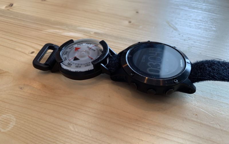
I carry a Garmin Fenix 5 GPS watch, which I use just for emergency navigation. Emergency navigation is for when there's zero visibility, no trail and adverse weather. The times when you don't want to be taking your phone out of your pocket every two minutes to check where you are.
I leave the watch turned off, but easily accessible in an outside pocket so I can get it when needed. GPS watches don't have particular big screens so trying to use a topo map isn't the best idea. Even routes or tracks aren't easy to follow. My tried and tested emergency navigation procedure is to create a set of kilometer marker waypoints for the entire route, and load these onto the watch along with any other waypoints I have for the trek. You can find these markers for our GHT route here.
In an emergency navigation situation where I've lost the trail, I'll first refer to my phone to work out where I am, and which waypoint I need to be heading towards. I'll then navigate to this waypoint on the Garmin. The waypoint list is ordered by proximity, so even with ~2000 waypoints the one you need will usually be near the top of the list.
My navigation home screen is configured to show me the bearing to the waypoint, the distance and the vertical distance. Bearing is the most important. Attached to the watch strap I keep an analogue compass (Suunto M-9). This has a sighting window, allowing my to get an accurate direction to the given bearing. The velcro strap that comes with the compass is perfect.
This method has worked in practise and got me out of a couple of tricky situations in the past. Once on top of the Pigne d'Arolla, descending to Cabane Des Vignettes in low visibility. That descent is notoriously tricky, with cliffs on one side and a serac field on the other. Another time in Iceland in zero visibility and horizontal rain we decided to locate Fimmvörðuháls Mountain Hut using the Garmin. Both times it worked flawlessly.

Dave
Normally a software engineer, recently I've been spending a bit more time in nature.
